Association of Citizens for Summerland

Tuesday, May 24, 2005

More on Golf Course Application

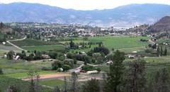
Further to Amie's post below, the developers of Summerland's proposed golf course and sprawling luxury residential subdivision have applied to purchase some crown land for the project. It's interesting to see the resort plan for "Giants Head Woodland Golf Resort", with its lush green fairways surrounding clear blue ponds. If you've ever walked through the trails in that area, you already know that it is a sandy desert with sagebrush and cacti -- it boggles the mind to imagine how much water from the aquifer will be required to create and maintain that unnatural landscape.

Land and Water BC is handling the application, and it looks more like a development corporation than a government organization acting to protect the interests of the public. The deadline for feedback on this application is June 18th. Comments can be sent through the LWBC web site or by mail to:
Drew Frymire
Manager Development and Marketing
145 3rd Avenue, Floor 3
Kamloops, BC
V2C 3M1

Monday, May 23, 2005

Application for Purchase of Crown Land

The plans for the proposed golf course west of Summerland are well underway. A notice of intention to apply for the purchase of Crown land has been placed. This application will be made under the All Seasons Resort Division, for a Crown Grant, for the purpose of a destination resort, golf course development with residential and resort neighborhoods and general commercial developments covering the proposed area.

[PENDING : APPLICATION UNDER REVIEW]
Client: 3093467 Nova Scotia LimitedPurpose: COMMERCIAL/GOLF COURSERegion: Southern Interior, KamloopsFile: #3410376
Apr 28, 2005
Location: Vicinity of Summerland Area (Hectares): 200.8 hectares more or less BCGS Mapsheet: 82E.062 Legal Description: Those parts of District Lots 3321 and 3403, and those parts of Blocks A and B of District Lot 3783, together with adjoining unsurveyed Crown land, all Osoyoos Division of Yale District

Maps of the location, along with plans for the golf course itself are available for viewing on the Land and Water BC site. The deadline for comment to Land and Water BC is June 18th. This is a "Big Time" development. How will this affect Summerland? There is a lot to consider.

Saturday, May 21, 2005

An Ambitious Alternative

The Natural Step philosophy is becoming a global movement. As a citizen, as a community, we have the opportunity to start taking some concrete steps toward sustainablility. It is becoming increasingly obvious that the old patterns of resource consumption to create economic wealth will eventually lead to a planet stripped bare. Let's choose a different course of action! Whistler, BC and Canmore, AB have already made this choice! Let's make Summerland a leader in the creation of a truly sustainable community. Have a look at The Natural Step, Canada website to learn more about this science based framework, helping individuals and communities take steps towards sustainability.

Here is an excerpt describing one of the first communities in Canada using this approach:

The Natural Step to a Sustainable CanmoreThe Town of Canmore, Alberta, in partnership with organizations within the community, has just launched The Natural Step to a Sustainable Canmore. This endeavour is an ambitious education, and planning process to help Canmore move strategically towards sustainability. Canmore will become the second Canadian community to implement The Natural Step’s community-wide engagement program after Whistler, British Columbia.At a launch event on November 25, 2004, attended by approximately 50 people representing the Town and local participating organizations, Canmore Mayor Ron Casey said, “This project will put Canmore on the map as a municipality that is actively seeking ways to balance humanity’s increasing demands for natural resources with decreasing availability.”The Canmore project is being led and coordinated by the Biosphere Institute of the Bow Valley. After two years of planning and fundraising, the Biosphere Institute secured a matching grant from the Federation of Canadian Municipalities’ Green Municipal Funds. Other funders include the Town of Canmore, the Canmore Economic Development Authority, Alberta Real Estate Foundation, Alberta Ecotrust, Three Sisters Mountain Village and the Community Initiatives Program.

Wednesday, May 18, 2005

Costs of Community Services

The term COCS refers to Costs of Community Services, meaning how various types of land use affect local government taxation and spending. There is a growing body of literature showing that residential growth on Farmland and Open Spaces actually results in a net taxation deficit to the community. To read more about COCS and the relationship between residential, industry/commercial and farmland/open land sectors, visit The University of Illinois , Government Finance, website. Here are a few excerpts to mull over:
Virtually all of the studies show that the COCS ratio
is substantially above 1 for residential land, demonstrating
that residential land is a net drain on local government
budgets. The average estimate ranges from about 1.15 to 1.50,
which means that for every dollar collected in taxes and
non-tax revenue, between $1.15 and $1.50 gets returned
in the form of local government and school
district services. On the other hand, the COCS ratios for
the other two land use categories are both substantially below 1.
For commercial/industrial, the ratio usually ranges from
0.35 to 0.65, indicating that for every dollar collected,
the local government provides only about 35 to 65 cents
worth of services. For agriculture and open space, the
ratios are only slightly smaller, usually ranging from o.30 to 0.50.


To me, this means that for every area of Farmland, or Open Land, that we develop into residential, we are creating greater costs to this community. The tax collected from these new developments will not sufficiently cover these costs, so either all of our taxes go up, or, we need to develop an equal ratio of industry/commercial properties to help offset those costs. It is actually our desire for more residential development that is creating the need for more industrial/commercial land.

Other researchers have attempted to measure the costs of
growth simply by measuring the statistical relationship
between population growth rates and per capita local
government spending. Most of these results have shown
that in areas with very small growth rates (in the range of
1 to 2 percent per year), costs do not escalate rapidly.
For communities with higher growth rates (above 3 percent
per year),
however, per capita spending begins to increase very
dramatically. The findings of the various types of studies
on costs of services seem to support the conclusion
that local public per capita spending increases when
farmland and open space are converted to residential
development.

I encourage everyone to visit this link. It is an interesting read and will shed some light on the true costs associated with the potential growth of Summerland.

Monday, May 16, 2005

Land and Water

I find this interesting. This is an exerpt from Mayor Tom Johnson's Report, November 8, 2004, as found in the Minutes, from the Municipal Website:

MAYOR’S REPORT (Nov.8, 2004)

He summarized the reasons behind the recent fact-finding delegation to California. He noted that our Official Community Plan has shown an expansion on our north-west boundary for more than 15 years. Agur Developments is looking at partnering with the Brandenburg Development Group from California on a proposed 27-hole golf course and 1500 residential units. During the visit to California our delegation
saw similar developments by this group and met with local government
officials. Mayor Johnston answered a number of questions with respect to
water supply, the ALR, and why the District is looking at this expansion
now. He noted that the development has its own water supply,
does not involve ALR land, and that the project has been on the books for approximately fifteen years.

Since that time, Summerland's boundary has been extended. I think as citizens of this town, we need to be kept more informed as to the implications of this. If a development takes place within city boundaries, receives the proper approvals, and pays taxes, will it have rights to power and a Municipal water source?

This is an exerpt from the Polaris Consulting Firm of BC:

The Land Development Process, p.2
It is also not uncommon for local governments to have a Development Cost Charge Bylaw in place, which means that while the local government takes responsibility for the installation and maintenance of utility systems, developers are required to pay fees at the time of the development to offset these infrastructure costs...


If you are in a municipality or an urban area your potable water is most likely supplied by the community. This could be in the form of a municipal service, a function of the regional district or a water improvement district. In each case, the Local Government Act governs the structure and the Ministry of Health Services
regulates the quality of the water.


Mayor Tom Johnson has referred to the fact that this development will have its own water supply; however, once the water distribution infrastructure has been built and paid for, will it then become the municipality's responsibility to maintain? What happens if the wells run dry? Will the municipality be responsible for ensuring potable water to this new community?

In addition, the private developer's Agent has now made an ALR exclusion application of adjacent Municipal Land. Hmmmm. How things change. This community needs to be kept up to speed.

Friday, May 13, 2005

Public vs Private ALR Application

I am concerned with the ALR Exclusion Application that has been filed by Robin Agur's agent on the 57 hectare parcel in West Prairie Valley. Permission for this application was given by Evan Parliament prior to the May 4th Open House. These are municipal lands. An application filed by a private developer does not follow the same process as that filed by a local government. I have included information from the ALC website:

Application by a Local Government

A local government may apply to include land into or exclude from the ALR for land within the local government's jurisdiction. The Applicant (the local government)

  • Must hold a public hearing.
  • Ensures that notice of the public hearing and the procedure at the hearing follow the requirements outlined in section 13 and 14 of the Agricultural Land Reserve Use, Subdivision and Procedure Regulation.
  • Completes the Application by Local Government form .
    Submits the application and fee (if applicable) to the Commission.

Application by Landowner

A landowner may apply to: include land in the ALR, exclude land from the ALR, subdivide land in the ALR, use land in the ALR for non-farm purposes
The Applicant:

  • Completes the Application by Landowner form.
  • Completes the notice of application requirements if applying to exclude land.
  • Submits the application, fee and proof of notice (if applying to exclude land) to the local government.

The most notable difference is the lack of a public hearing for applications by a private land owner. I question the intention of the Municipality allowing a private party to make this application on behalf of public lands. I feel the public should be given the right to attend a public hearing to discuss the specific reasons for an Exclusion Application at this time, as well as what specific plans have been made for the use of this land. It is currently designated Future Residential. Has this changed?

I am concerned with the process here, as well as the apparent close ties between Municipal staff and the Proposed Golf Course Development. I believe our local government should remain at an arm's length from any private development proposals.

Thursday, May 12, 2005

OCP Presentation

The Summerland Municipal Website has made the recent Open House presentation available on-line. If you have Adobe Acrobat Reader, (which most people have), you can view full maps of the proposed ALR exclusions, along with the ALC comments on each parcel. The municipality is accepting comments on all of these ALR issues. You can ask for the forms at Municipal Hall. Make your opinions known!! Check it out here, ALR exclusion presentation. It would be worthwhile to also foward your comments to the ALC directly. You can call Martin Collins, Summerland area planner, at 604 660-7021 or e-mail your concerns to Martin.Collins@gems9.gov.bc.ca.

Information on the Water Use Plan is available as well.

Monday, May 09, 2005

Why I love it here.

My five-year old son, Zachary, and I went for a bike ride today. We live out on Prairie Valley, and he wanted to head down to Giant’s Head School. He is just learning how to ride on the road, so we went down Dale Meadows instead of Prairie Valley. Round trip takes us about an hour, and it is always such an exciting experience! Today we spent quite a while checking out the goats and sheep, lambs and kids, jumping and playing. There are llamas too, and a great big turkey that gobbles his head off as we go by. There were two mallards sitting right on the road, the usual quail, and we also saw a killdeer and several red-winged blackbirds. We saw horses too, a miniature, and a new foal.

We rode by Grandma and Grandpa’s, past the corner store, to the school playground, then cut back through some fields, along Prairie Creek, and back home, just my five year old and I, and all inside of an hour. This is why I love Summerland. It’s small. It’s safe. It’s wonderful.

Friday, May 06, 2005

We need to recognize that this Water Use Plan does not address our changing weather patterns or make provisions for that eventuality. This plan's simulation model used snow melt and storm information from the last 67 years. According to Environment Canada statistics, 5 of the warmest winters on record have been in the last 10 years. The last 5 winters have been drier than normal, with the winter of 2004/05 being 20 % drier. Climate change is not a problem of the far off future. Climate change is NOW. This Water Use Plan was necessary and is a start in the right direction; however, our decision makers have a long way to go before they can say that Summerland's water problems are under control.

Well, How about that Open House?

The Water Use Plan has been revealed. What does it all mean?
Mr. David Sellers, Plan Consultant, gave a very detailed and interesting presentation on the Plan. I will quickly summarize here for those who did not attend the meeting:
  • The watershed model is based on the flow data from Camp Creek, which is 5% of the total watershed. This data is then extended to the entire watershed. (Is 5% a large enough sample?)
  • Water consumption data has shown that in 2002 Summerland's usage exceeded the calculated demand, and in 2003 and 2004, our usage was less than the calculated demand. This shows that there is a potential for conservation methods; however, you will remember that in 2003, there was a complete ban on residential lawn watering.
  • Our new water use plan will include "real time" flow indicators and a trigger graph that will determine our stage of water restrictions and balance that with flows for the fish.
  • The operating agreement that has been reached will provide certainty for Summerland water users and security for fish flows. It also targets water use reductions. The precise details of the agreement will change somewhat, allowing more water for the fish habitat once Thirsk Dam is expanded.

Some key points about this Water Use Plan that came out during Question Period:

  • When modeling was done that looks ahead in time and takes Climate Change into account, it shows that the Trout Creek Watershed CAN NOT provide for all water stakeholders and additional water source will HAVE TO BE FOUND.
  • The population base that was used for this model was that of 2002. This is a plan for TODAY and does not take into accound any amount of population growth. Repeated: there are no projections for population expansion in this model or agreement.
  • The Prairie Valley reservoir will continue to be used as a final catchment before the water treatment plant and so far, no leachate from the landfill has been found. (Thank Goodness! I wonder how long our luck will hold out on that one.)
  • Water consumption in the district has decreased over the last 20 years. Their guess as to why is that we use better irrigation practices. I wonder if it may be the reduction in the number of farms as well.

So, lots of information, and I think it is great that the Municipality hosted this presentation and the Question Period. This Water Use Plan appears to be a fair agreement and a good compromise for our water users and the protection of fish habitat. However, I am disturbed by the fact that any amount of population growth will have a direct impact on this balance, and it seems that this has not been addressed. At least not by this Plan. Mr. David Sellers made this very clear. This Plan does not address climate change or population growth. Council can not use this plan to answer the community's questions of growth will affect our water availability. It simply did not address this question at all.

YIMBY (Yes, In My Back Yard)

One of the issues for an association that defines itself by its opposition to development is that the focus will tend to be negative. It invites the charge of NIMBYism (Not in My Back Yard). That isn't always necessarily a bad thing, since fighting environmental damage or developments perceived to be detrimental to a community are ways of keeping our "back yards" in good shape, but the approach doesn't usually provide any vision for the future other than the status quo.

I found this story fascinating in that context. A neighbourhood association opposed the design for a bank branch that wouldn't have fit into the community, but they recognized that the neighbourhood really could use a bank. So instead of the usual NIMBY opposition, they took a YIMBY (Yes, In My Back Yard) approach and offered to work with the developers to come up with a better design that made more sense than a giant parking lot on a busy corner.

And it worked! They got a bank branch without sacrificing the spirit of their street. I think we should take this lesson to heart, focusing on the proactive approach.