Association of Citizens for Summerland

Monday, March 28, 2005

Newsletter #3

I sent out the third newsletter this weekend. If you'd like to subscribe, add your e-mail address to the box at the bottom of the right sidebar and you'll get an e-mail update every few weeks about new posts or events in Summerland.

Sunday, March 27, 2005

Cartwright Vistas and 53 Hectares of ALR

I'm a bit of a map junkie, and I was looking at OCP maps again tonight. My eye kept returning to one area. This graphic shows a small section of the Urban Growth Area Map proposed in Draft 2 of the OCP that I think we should be paying more attention to.

Here's why:
  • The pink/red shows existing development and areas slated for development in the near future (before anything in the Future Growth Area is developed), so we're not talking about the distant future.
  • It contains the 53-hectare block of ALR land to the north of the downtown core that will likely be controversial. Is it close enough to downtown that residents will actually choose to walk to Giant Foods? Probably not, but it's the closest "available" land to the commercial centre.
  • Look closely at how much of Cartwright Mountain is slated for immediate development -- everything west of Cartwright Ave. It's a huge area and much of the east side is visible from everywhere in town. The potential for a Westbank-style clearcut 'n gouge hillside development is just a little too scary.
  • Don't think they'll allow an ugly and illogical hillside development on Cartwright? Then ask yourself this -- why on earth did they allow Deer Ridge to be constructed with no sewer lines anywhere near it? Why didn't the developers have to pay for infrastructure upgrades before plopping a bunch of homes up there? Now we'll all be paying for it, subsidizing their purchases (and profits) from five or ten years ago. At a glance, Cartwright Vistas and North Prairie Valley look like more plans for classic monster-home sprawl.
There may be other areas proposed in the Urban Growth Area that people will have issues with, but I'm thinking that this little map shows where much of the debate will (or should) be focused. What if the UGA boundary was tightened up to include maybe half of that block of ALR land and half of what's proposed for Cartwright hillside development? Perhaps we could even get creative and include stipulations for leaving trees in (Deer Ridge is actually pretty nice on that count), protecting sight lines from town and including zoning for multi-family, higher-density development in those new areas? What about smaller lots with smaller, more affordable homes? Protecting and encouraging public access to trails in the area? I know, I'm probably just dreaming.

Oh, and the Jersey Lands show up as a bizarre and disconnected block of pink nowhere near any serviced areas, totally stranded out there on the side of Conkle Mountain. It obviously has no business being part of the Urban Growth Area for Summerland, and maybe not even the Future Growth Area. I have no idea what they were thinking -- the costs of creating the necessary infrastructure should be prohibitive.

Finally, take another look at the full map and try to figure out why the proposed golf course way out on the municipal boundary has anything to do with coherent and logical regional planning. It could almost be hilarious if it wasn't so serious.

Tuesday, March 22, 2005

Molybdenum Mine in the OCP?

This story isn't really related to our OCP process, but it looks like two mining companies are considering a molybdenum mine in our watershed. This press release is short on details, but one of the companies has this profile on the property:
"Crowrea Project is a Molybdenum prospect and is approximately 3,440 hectares (8,500 acres) in size.

Location: Located 15 miles south of Brenda Mines in the Osoyoos and Similkameen Mining Division near Summerland, B.C"

So that's a pretty big chunk of land, and it appears to be near Trout Creek, northwest from Faulder. It's outside of our district boundaries, which probably means it's a provincial responsibility. Note that the press release isn't announcing the opening of a mine, but they're planning a work program to reassess the potential of the property.

Some of you may have followed the related controversy just up the highway from us in Peachland in the '90s. Several million cubic metres of molybdenum-contaminated water from Brenda Mine was discharged (and is still being discharged) into Trepanier Creek and the lake. I suppose there will be business-oriented Summerlanders in favour of the employment a mine could bring to the region, but I hope they can learn from Peachland's experience to look into our future first:
  • An article about the battle over the decision to discharge molybdenum into Peachland's water supply (and into Okanagan Lake) from the decommissioned Brenda Mine
  • More about the process of decommissioning the mine, including some account of public consultations
  • Noranda's information page on the Brenda Mine, including health information on molybdenum levels that looks like it might have been written by Montgomery Burns

Monday, March 21, 2005

Open House Survey - Detailed Results

Poking around the municipal website tonight I came across an in-depth breakdown of the results to the municipality's open house survey. There's a lot here to digest, in a decidedly unbiased presentation. The comments section is particularly interesting; with respect to many of the more contentious issues (the proposed golf course, ALR land, highway development, etc.) the comments were weighted very heavily in favour of a more moderate, cautious approach. Of course the number of respondents that took the trouble to write their own comments was very small, so statistically these responses may not be as meaningful as I initially took them to be. Nevertheless, there has to be some significance to the fact that of those that responded, 29 people were in opposition to the proposed golf course versus 2 in favour, 28 people want land left in the ALR versus 6 in favour of small parcels being removed, etc. You get the idea.

At any rate it's interesting to compare the results here with the results of the unofficial survey referenced below; they're not all that far apart and overall seem to indicate an unmistakable preference for a careful and thoughtful approach to development here in Summerland.

Second Survey Results

Tony Cooke has emailed us the results of the survey that he and his group of concerned citizens distributed at last month's open house (and online here). He's in the process of compiling them into a single report for presentation to Council today (Monday) and submission to the Review for this Thursday, but was kind enough to forward the raw results to us over the weekend.

Of particular interest were the first two documents, providing an indepth summery of the votes cast and a comprehensive list of the comments received.There's a lot to process and discuss here, but we wanted to get it online as quickly as possible, so feel free to dig in and we welcome any comments! Thanks to Tony & co. for the "scoop".

Update: Tony provided a new updated document that combines the survey results and comments -- view the new PDF here.

Friday, March 18, 2005

Open House Concerns

The Summerland Review reported the results of the open house survey, which were released at the last council meeting:
"Of 294 survey forms completed, 219 listed the community plan as the top concern. The boundary extension at the western edge of the municipality was cited in 164 forms. The water use plan was listed 189 times, but other water-related issues were also identified. These included Thirsk Dam, the water treatment plant and water separation. Water issues were also raised in 64 comments."

I'm not sure how valuable it is to know the "concerns" without finding out how people feel about each one, but I guess it's good to know that there are significant numbers of people who care about these things.

Sustainable Prosperity

The Penticton Western ran a great article last week, covering a valley-wide research study that tried to identify the best possible futures for the region. It's called the Okanagan Sustainable Prosperity Strategy (PDF). A quote from the introduction that could be applied to Summerland's OCP process right now:
"There are forces at work that have made this the right time for new thinking and action on shaping our region's next steps in development. The Okanagan region stands at the proverbial fork in the road where difficult choices must be made. Very rarely does a community have the opportunity to choose its future. More often changes take place incrementally, invisibly, and one morning residents wake up and realize that the qualities they knew and loved are no longer there. The Okanagan Partnership for Sustainable Prosperity is about taking responsibility for protecting what is important today while setting the stage for enabling what is desired for tomorrow."

It goes further in by painting two very different pictures of the Okanagan's future. Of course they're extremes, and the timeline is probably too compressed, but it's a fascinating thought experiment. First, the bad news:
"Sunshine Eclipse: In 2014, the region wakes to a sun shrouded with haze and a land turned over to asphalt and automobiles. Gone are the apple and cherry orchards, long ago replaced by fast-food outlets. The drive from Kelowna to Vernon has become an unceasing pattern of strip malls, subdivisions, and office parks. Jobs and housing abound but too many of them are dead-end low wage jobs with little opportunity for growth and pay too little to enable homeownership. Further, there is little evidence of natural landscapes except for the increasingly rare view of the lake and the distant hills. However, that view is more a mirage than an affirmation of the region's once great quality of life. The lake has constant swim advisories. Cities and communities in the region seem to be at constant war for both tax dollars and new development. In short, a new feudalism has emerged. This was the Okanagan that no one ever imagined could develop."

Pretty bleak, and it's exaggerated for dramatic effect...but driving between Kelowna's downtown and OUC this week made the possibility seem all too real. Sprawling box stores, highway development, isolated suburbs, nasty traffic and brown haze in the air, and don't even get me started about the slash 'n burn hillside developments on Westside. But the report goes on to paint a much rosier picture of the other potential future:
"Sustainable Prosperity: In this scenario in 2014, the region wakes up to look out at an Okanagan where environmental protection goes hand in hand with economic prosperity. The preservation of the region's natural assets indeed became the region's greatest economic asset. The Okanagan has become a little paradise in the mountains an island community surrounded by wilderness yet well planned with distinct community character. The universities and research institutes are well respected nationally and have developed a successful track record in commercializing technology. Growth is guided by regional goals and development enabled by strategic investments. The regional districts and First Nations strengthen their identities and work in a complementary manner. A new collaborative culture takes shape. 10 years from now, the Okanagan becomes a model for growth with sustainability."

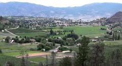
In Summerland, the "Sunshine Eclipse" isn't going to happen any time soon, but sustainable prosperity would seem to be a respectable goal. Read through the last quote again with this little town in mind -- it sounds just right.

Thursday, March 10, 2005

Agricultural Land Development

Tony Cooke has been corresponding with our Agricultural Land Commission (ALC) planner Martin Collins about Council's request to the ALC to remove some land from the Agricultural Land Reserve (ALR). It's not clear how much land is in question, or which specific parcels are being considered, but Mr. Collins offered this advice:
"There will likely be no formal public information meeting. However, the public are encouraged to provide written comments to this office in the next several weeks."

The application may not be for the ALR land slated for development in the second draft of the OCP, but it would be great to find out what exactly the request is for. One would hope that we'd be finalizing the OCP before getting into the process of having land removed. If you have an opinion or want more information, e-mail Mr. Collins (Martin.Collins@gems9.gov.bc.ca).

Growth Not Meeting Projections

Councillor Carla Wright has sent us a few excellent e-mails giving some background into Summerland's water issues and OCP points. I asked if I could include an excerpt from one of her letters because I think it's an interesting argument that deserves some discussion:
"Our existing OCP that dates back to 1996 had a projected population of 12,209 by 2005 and that figure was based on a 2% increase over the 10 year period leading up to 2005. To date we have not met that projection and many people question the rationale of putting too much stock in projected population increases. The 2nd draft of the new OCP suggests at a minimum this community will grow to approximately 18,270 people by 2026. At less that 2% growth this community will exceed the amounts agreed to by the stakeholder's group that provided input to the OCP process. They are advising that the community maximize its population at 17,000 by that time.

We have experienced large growth rates in the past for short periods of time. We will see them again in the future, however, the certainity is that this community has and will continue to have a large proportion of seniors and because of that age group the population trends have remained relatively flat. Certainly, Summerland will grow, but historically it has not met projections."

She also made a solid point about the council's role in controlling growth:
"Controlling where growth occurs to ensure that our community retains its small town atmosphere, that our water and other services are adequate to meet our needs are worthy to pursue. Setting a defining limit and closing the door after that 17,000th person enters will appear very unrealistic to the next person who is 17,001."

This last point is worth pondering. If you could wave a magic wand and find out how everyone in the town felt about newcomers, you might find that the longer people have been here, the less growth they want. People like me who have arrived more recently don't necessarily love the community any less, and we may be more likely to want to share it with people who come after us...as long as it doesn't wreck what attracted us in the first place. Gross generalizations, I realize, but food for thought.

Wednesday, March 09, 2005

Rezoning Meeting in Faulder

A notice has been sent to all Faulder and Meadow Valley residents regarding a meeting to be held at Camp Boyle on March 16. It concerns a rezoning application and the plan for a residential development between Faulder and Summerland.

I am posting this entry as this meeting may be of interest to people living outside the Faulder/ Meadow Valley area.

The notice reads exactly as follows:

ATTENTION
ALL FAULDER AND MEADOW VALLEY RESIDENCE

The Gibbs family invites you to attend an information meeting about the Gibbs family plans for a residential development on our 120 acre estate in Faulder.

We wish to inform our community of our plans for our rezoning application and eventual residential subdivision.

[Regional District of Okanagan-Similkameen ariel photograph of area in question]

Meeting is on Wednesday March 16, 2005 at Camp Boyle.
Meeting starts at 7:00 pm.
Everyone is invited.

Monday, March 07, 2005

Don't say you didn't know!

Like many of you, I receive my Summerland Utility bill online and as such I receive the District's newsletter that way, too. An interesting note in this issue deals with the municipal boundary extension that was just passed - this is the 377 hectares of land to the west of town, site of the contentious golf course development. Here's the blurb from the newsletter:
Summerland Council has received word from the Province of BC that the District’s request to extend our boundary to the west to encompass 377 hectares of land has been approved.

Development of these lands could have taken place while the lands were within the Regional District of Okanagan-Similkameen which would have meant that the District of Summerland had little say in how they were developed. As any development in this area will impact Summerland, Council made the request for the boundary extension so that the lands fall under municipal development control. By placing them within Summerland’s boundaries, any development will have to comply with the land use and development regulations of the District.

Before development of the lands can begin, the developers will be required to go through the public approval process where all of the land use issues, environmental concerns, servicing and infrastructure issues will be addressed. There will be numerous informal opportunities for public input and there will also be the formal legal processes of public hearings on the land use bylaws.

Watch for additional information on this topic in future on [the district's] website...and on upcoming Council meeting agendas.
We can't say we weren't warned here; many folks out there have expressed very strong feelings about both this boundary extension and the proposed golf course. Many have also complained, rightly or wrongly, that decisions such as these are being made without adequate opportunity for public input - it seems the framework for such input is being outlined above; if you are passionate about this issue, make it your business to know when and where these hearings take place, and how and to whom you can direct your concerns.

...and in the save-a-tree department, you can sign up to receive your utility bill online.

Newsletter #2

I sent out the second newsletter last night. It's a way to keep up with updates to the site, and events or deadlines in Summerland related to development and the OCP. Add your e-mail address to the box at the bottom of the right-hand sidebar to subscribe. Here are some of the highlights I included this week:
I'm guessing that most of the readers of the site and this newsletter attended the public open house. Bill had a good post with his post-event thoughts, and there is a discussion emerging in the comments below. What did you think of the open house?

Council seems bent on a more aggressive growth rate than what the stakeholders recommended (and ramped up the rate of the first draft's 2%). I posted about the issue tonight, and this older post also some good discussion about what power council has to limit growth.

Tony Cooke sent me a copy of the "terms of reference" for the Stakeholders Committee and I added it as a comment in this discussion of the role of the stakeholders.

Our most frequent commenter, Frank Martens, put a fair bit of work into a couple of comments in the past few weeks, including an in-depth account of his exchange with council about an ALR exclusion. Scroll to the bottom of this post to read it.

In response to a post from a frustrated local orchard owner who wants his land out of the ALR, we got a comment from a successful orchardist who doesn't really agree.

Sunday, March 06, 2005

Growth Rate

In looking back through the second draft of the OCP just before the open house, I was struck again by the text inside the little box at the bottom of page 27:
"Following the presentation of the first draft Plan to District Council, Council determined that the UGA, as proposed in the first draft Plan, did not meet their objectives of providing additional lands for economic development. Council requested municipal staff and the OCP consultant to provide a revised UGA."
So apparently council got the first draft from the consultants that apparently recommended a more aggressive growth rate than the 2% annual growth the stakeholders committee had decided on...and council felt that the rate of growth should be at least 4%, which would be two or three times higher than our current growth rate?

In looking through the stakeholder's meeting minutes and the parts of the OCP that cover public input, council just doesn't appear to be representing the interests of the citizens on this one. It makes you wonder if we really should be worrying about how much ALR land needs to be developed or which hillsides are best for subdivisions -- with a slower growth rate and smart infilling, neither should be necessary.

Laura's Letter

Thanks to Laura Dean for this e-mail about an article in the Review this week. If anyone has any insight or answers to her questions, please leave a comment.
Council Accepts Proposal for Water Treatment Plant (Summerland Review, March 3, 2005) has a few interesting items. The golf course resort is apparently expected to add 1200 to 1500 houses to the community. I have a hand out from the Open House that suggests that the annexed land for a new golf course, is proposing 700 to 1000. This is a substantial difference and I would like to know which one is correct?

Also at the end of the article, Peter Gigliotti, an engineer with Urban Systems, is quoted as asking "The larger question is can we get enough water to the plant in a drought condtion." Is the Thirsk Dam expansion really going to be the answer to our water problems as council is claiming it will be? I would like to know on what information Mr. Gigliotti is basing this question on and why this information has not been made public to the citizens.

I apologize if I have missed some data or comments from past news releases etc. that would have explained Mr. Gigliotti's concerns. Perhaps this is not as troubling as it seems, but to me when an engineer of an experienced firm, such as Urban Systems, goes on record with such a statement then I start to feel a little uneasy about some of the decisions Council is making to keep our water flowing."

Common Planning Fallacies #5

Tony Cooke has been thinking about more planning fallacies. Here's the fifth installment:
Fallacy #5: "We don’t need to worry about excessive growth because the lack of water will be the controlling factor."

Tony's comment: "This is wishful thinking. Our (temporary) limited water supply might subdue growth for a short while. Engineers and developers are creative and intelligent. Huge cities (like Phoenix) have been built in the middle of barren deserts. Water conservation, increasing our water supply from the mountains, and extracting water from the lake, are comparatively simple things to do. The greatest pressure on the ALR will come because developers will covet the water which agriculture presently uses."
What do you think? It seems like council is embracing the water issue and pushing for more aggressive growth rates than the town has had before. Also see #1, #2, #3 and #4.