Parks And Rec Commission Wants Public Input at Meeting
The Commission members have confirmed that they want input from the public at Thursday's meeting to discuss the Little Giants Head land swap. Apparently several people in favour of this development will be attending. If you oppose this deal, attend the meeting and say your piece
posted by tony cooke |
Permanent Link
![]()
![]()

11 Comments:
The following letter was given to the Rec Commission on Wednesday, Aug 17th as I was unable to attend the meeting due to my work schedule.
David
August 16, 2005
Dear members of the Recreation Commission,
Ten years ago last Sunday Council unanimously passed Bylaw 95-035 giving the majority of the municipally owned lands around Little Giant’s Head park zoning. Although a portion of the municipal property bordering the
road by The Glenfir School and located immediately to the west of the base of Little Giant’s Head was not included in the park in order to facilitate some additional housing in the area and the possible extension of that roadway southward to Sage Road the majority of the municipally owned lands were zoned parkland in order to preserve this land for the use and enjoyment of the residents of Summerland and to protect this land from any further housing development.
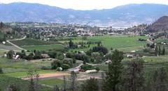
Although Little Giant’s Head Park is not a very well know park in
Summerland it is well used by residents of the immediate area as well as others from the community. I know that several of you have walked this property and hopefully others have as well. If you have visited the site you know that it is easily accessible from Alder Street, and the walking trails at the end of Palmer Place and Pollack Terrace as well as from a
trail leading from the road near The Glenfir School.
While the proposed land swap would provide some recreational amenities including a trail, picnic tables, etc the vast majority of what is currently parkland would be alienated from public use and turned into a
subdivision. The land that would be acquired under the proposed land exchange is not as accessible to the public and except for perhaps a small portion at the southwest corner is not accessible via public land. It is for all intensive purposes “landlocked”.
I would hope that as an advisory body, providing input into recreational and park issues in our community, you would oppose the dismemberment of Little Giant’s Head Park. I would also like to suggest that you recommend to Council that actual park dedication be applied to title to
various parks throughout Summerland. As many of you will recall previous councils have attempted to sell off portions of the Living Memorial Ball
Park on Snow Avenue, and have tried to turn Peach Orchard Beach Park into a campground and have even attempted to turn portions of Memorial Park into a parking lot. Our parks deserve better. Giving them park dedication would help preserve them for future generations.
Sincerely,
David Finnis
By Anonymous, at 7:09 p.m.
I attended the meeting tonight, along with about 60 others.All the land commission volunteers were there. Carla Wright, a new assignee to the PRC chaired the meeting.
Mr Murphy gave a good presentation,from his position.
We did,however, have about 10 in the audience who clearly said "no" to the proposed land swap.
We had the professional input from a forester, a biologist and a parks and recreation planner,who lives at the foot of LGM,and who works outdide this area. I was please to hear concern for the habitat, the flora and fauna as well as the inherent value of the land as a park,that will increase exponentially with each generation.
Briefly, "we" came out of the meting with more than I anticipated,and others, I am sure.We had 2 motions from 2 of the PRC and both were carried., to be taken to council:
The first motion proposed that the area be made an official dedicated park.
The second asked that the area become included as park land under the PRC official planning process.
Yah!
Laurie Rockwell
By Anonymous, at 8:52 p.m.
Laurie has written a good review of the meeting. All of the people who made comments about the land swap came out strongly against it. We can only hope that the mayor and council take the recommendations made by the Parks commission to heart. But of all the commentators, I was most taken by the chap who used the same overhead projections maps as the developer, but by expanding them into a relief map made it possible to visualize the altitudinal difference between the two areas. This made it patently obvious why the developer preferred Little Giant's Head to his own property. Well done, Sir.
It would be nice to have the Review print the same map in full colour, so that the residents of Summerland who were not at the meeting could also see what an unfair deal was being offered us.
This is the kind of process that we are going to have to go through much more frequently in the future. It is up to members of the Association to be prepared with visual aids, with researched data, and, hopefully, with a good representation of the community to help back you up. It was good to see so many people show up who might not normally participate in this type of meeting. It was also good to hear Carla Wright mention the number of people who had taken the time to write to the Commission in advance of the meeting. I don't know how much weight these letters carry with Council, but, added to the comments they heard from the public this evening, the Commission certainly got the idea of how the "vociferous minority" felt. Now all we have to do is turn the minority into a majority by November. Good work, all.
10:45 pm Aug 18th
By Anonymous, at 10:43 p.m.
The "chap" to whom Frank refers above was me. I have placed the image in question, which showed the terrain coloured according to steepness of slope, at my website, which should be listed below. A number of other images of interest are also there.
These images attempt to show where the property boundaries are now and where they would be after the swap, in relation to the terrain on the mountain. These boundaries are approximate, gleaned in part from the poor map published in the Review (I asked for a proper definition of the proposed park boundary fom the city, but, to my surprise, they do not have it). The Murphy lands are on the right. For linear scale, the lower edge of the Murphy lands is about 400m (or a quarter mile) long.
Note that the colour slope map that I showed at the meeting is also shown "draped" across a 3D terrain model viewed from various angles, for an even better representation of what is what. The colours on these slope maps denote slopes up to 35% in shades of green, yellows are up to 50%, and reds are steeper than that. As a sort of reference, the climb from the parking lot to the viewpoint on Giant's Head shows up as yellow in this representation (not on the maps shown here). Contours in the maps are at 10m (33ft) increments, with heavier contours every 50m (164ft). The top contour on Little Giant's Head is 690m (2264ft).
It is clear from these maps that Mr Murphy has just drawn a line around the green parts, leaving only steeper lands in the proposed park. The slopes around the south side are extreme, and the proposed trail there would involve a climb of over 50m (164ft) up the steepest terrain on the mountain.
This proposal does not leave Summerland with the asset that Mr Murphy would want everyone to believe. All of the supposed benefits of his proposed park already exist in the park, and much more besides. Please stand up and be counted and save the park for now and for the future.
By Anonymous, at 7:04 a.m.
Ah, I see now how this works. Click on my name above to get my website.
By Anonymous, at 7:07 a.m.
Excellent, Andrew. Thank-you very much for making this available for all to see. I checked out all of your maps and from what I could tell, the South East side, the red, steep side, is what Murphy is offering up to the public, while the North West side, the green, gently sloping side, is what the public already owns. Is this a fair assessment? As far as I am concerned, some picnic tables and an interpretive plaque don't make a park. Murphy is taking far more than he's giving with this deal.
By Amie, at 4:39 p.m.
Amie, yes, Murphy wants essentially all of the "green" lands that the municipality owns now (the summit and saddle plateaux and the western slopes), in exchange for the "red" and "yellow" areas of his lands (the south-east and eastern slopes).
His proposed trail runs from the Alder access point, at the north-west corner, around to the "green" bench in the west, where he would place his picnic area. The trail then continues down-slope to the base of the red area. This much of the trail already exists, by the way, and someone has recently marked it with pink ribbons.
From there he proposes to carve a trail traversing up-slope across the steep and rocky south-west face almost up to the summit plateau (more pink ribbons are visible on trees starting up this route if one looks carefully). The trail then descends on the other side to his proposed "trestle view" area, then continues to join up with the end of Fenner St. (which is now just a glorified driveway) in the east.
The park now is a far more valuable thing than the park of Mr Murphy's vision. There is no recreational opportunity offered by his plan that is not already available in the existing park, and there is much to be found in the existing park that is absent from his plan. Much of the existing trail network would be lost, for starters. That there are no trails on the lands that Murphy proposes to put into the park speaks volumes: nothing stops people from going there, but they choose to spend their time elsewhere.
Park users do not go there to seek picnic tables or groomed trails that offer no possibility of a wider adventure. They go there for an "unstructured" experience in a wilderness area. No "improvements" are needed.
By Anonymous, at 8:08 p.m.
Hi folks, Laurie again.
I was encouraged by Lisa Scott's impassioned plea to consider not just the'human'values of said land,but the flora and fauna values as well. Too often we forget that we are not the only living thing that depends on large and small tracts,nooks and crannies and corridors to be fruitful and multiply.
As the Ecological Warden for the Trout Creek Ecological Reserve(ER) above the S'land Golf Course, I have spent the last 2 years looking for a native red-listed plant, Columbia Goldenweed(Pyrocomma carthamoides)on the ER and all the mountains around Summerland.
I have now found sites on Conkle, Rattlesnake,behind the Research Station and just this weekend, 3 sites at the S,NW and SW foot of GHM and 4 sites on what I believe is the land Mr Murphy wants to develope.The sites had 10 to 39 plants and I found individual plants throughout the site in appropriate habitat.I GPSd all the sites and can make the coordinates available to anyone who wants them.I plan to give all these site locations to the Consevation data Centre in Victoria.
So now we have another non-economic/development reason to support a dedicated park in perpetuity.
All my relations........
By Anonymous, at 12:14 p.m.
I'd love to see this conversation expanded to include more of Summerland's incredible green spaces. The last draft of the OCP proposed housing developments for most of the east and south sides of Cartwright Mountain, the lower south sections of Rattlesnake Mountain, and the east side of Conkle Mountain (Jersey Lands). All three areas also contain trails, wildlife habitat and natural beauty similar to Little Giant's Head (and lands already wisely protected on Giant's Head).
I don't bring this up to take the focus away from protecting LGH -- I support everyone's efforts to make sure we (all citizens of Summerland) aren't getting a raw deal in the land swap. However, I wonder whether we shouldn't be trying to take a bigger-picture view of the land use issues surrounding the town. I worry that choosing LGH as the only/main greenspace issue may lead to a case of winning a battle and losing the war.
That said, I'm hopeful that many of the people who feel strongly about this specific issue may also get involved in protecting Summerland's other beautiful undeveloped spaces. Perhaps the association could help faciliate a network of people who wish to work with the municipality on a long-term parks and wilderness plan?
By Jeremy, at 11:34 p.m.
The decision made by the membership on Wednesday for the Association to join SmartGrowthBC will probably answer your concern, Jeremy. LGH was the focus (and must remain so until Council adopts the motions passed by the Parks and Rec Commission) because of the extreme urgency of the situation.
Smart Growth principles include protecting and enhancing parkland, and preserving buffer zones. I expect this topic will be included in the workshops SmartGrowthBC will run for us.
By the way, all Councillors, present and prospective, will be invited to take part in the workshops.
By tony cooke, at 11:20 a.m.
Great news, Tony. As I commented to the post announcing the Smart Growth BC membership, I think this an excellent decision.
By Jeremy, at 4:33 p.m.
Post a Comment
<< Home